


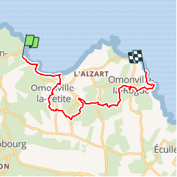
Port Racine le Port du Hâble

Laurent53
User

Length
10.1 km

Max alt
98 m

Uphill gradient
222 m
Km-Effort
13.1 km

Min alt
0 m

Downhill gradient
235 m
Boucle
No
Creation date :
2018-04-17 20:18:31.849
Updated on :
2018-06-17 12:37:24.759
2h40
Difficulty : Unknown

FREE GPS app for hiking
 SityTrail
IGN / Geographical institutes
SityTrail Plus
The world is yours!
About
Trail Other activity of 10.1 km to be discovered at Normandy, Manche, La Hague. This trail is proposed by Laurent53.
Description
rando facile ,en famille.
Positioning
Country:
France
Region :
Normandy
Department/Province :
Manche
Municipality :
La Hague
Location:
Saint-Germain-des-Vaux
Start:(Dec)
Start:(UTM)
579474 ; 5507177 (30U) N.
Comments